


Beschreibung von BackCountry Navigator XE: Outdoor GPS App (New)
Welcome to the next generation of a product for exploring the outdoors on your own terms, using offline topo maps and GPS on your smartphone.
You can also subscribe to the XE List to get notified of status, updates, and deals.
While many of the goals of the new app are the same, we are hoping to achieve a number of goals with the new platform:
Cross-Platform
The original BackCountry Navigator PRO is only available on Android. We will be bringing BackCountry Navigator XE to Android, iOS and the web.
The corresponding app for iOS will be launched through TestFlight
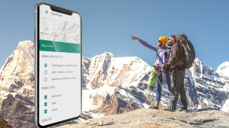
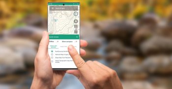
Planning In The Cloud
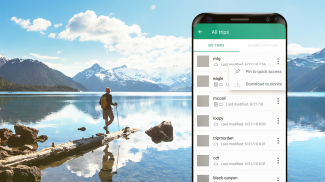
The website bcnavxe.com is the web interface for BackCountry Navigator XE. With it you can plot points, routes, and boundaries for trips, and download them on demand in the mobile app. You can push trips created in the mobile app to the cloud as well for reviewing or sharing.
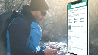
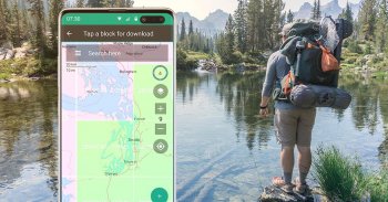
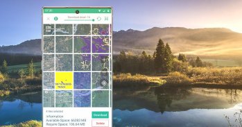
Easy Grid Based Download of Maps
You can try out a simpler approach for downloading and organizing offline maps, choosing large squares at a time. Visualize what you have and what you need.
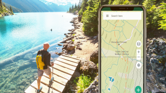
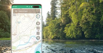
Vector Topo Maps for the World
Vector topo maps for the world hold the promise of crisp multilevel detail, with the ability to download large chunks of the earth's surface in a quick, compact operation. The BackCountry topo map for the world can be viewed in this app and on bcnavxe.com, with an easy process to install them in large blocks.
SALE: 5 and 10 year plans now available for a limited time at bcnavxe.com.
Use coupon SUB2020 to save even more before the end of the month.
If you are looking for an already proven and established product, also consider BackCountry Navigator PRO. Support and development of that app continues on a parallel track.
https://play.google.com/store/apps/details?id=com.crittermap.backcountrynavigator.license
Willkommen bei der nächsten Generation eines Produkts, mit dem Sie die Natur auf eigene Faust erkunden können, indem Sie Offline-Topokarten und GPS auf Ihrem Smartphone verwenden.
Sie können auch die XE-Liste abonnieren, um über Status, Updates und Angebote informiert zu werden.
Obwohl viele der Ziele der neuen App gleich sind, hoffen wir, mit der neuen Plattform eine Reihe von Zielen zu erreichen:
Plattformübergreifend
Der ursprüngliche BackCountry Navigator PRO ist nur für Android verfügbar. Wir bringen BackCountry Navigator XE auf Android, iOS und das Web.
Die entsprechende App für iOS wird über TestFlight gestartet
Planung in der Cloud
Die Website bcnavxe.com ist das Webinterface für BackCountry Navigator XE. Damit können Sie Punkte, Routen und Grenzen für Reisen zeichnen und diese bei Bedarf in der mobilen App herunterladen. Sie können in der mobilen App erstellte Reisen auch zur Überprüfung oder Freigabe in die Cloud übertragen.
Einfaches rastergestütztes Herunterladen von Karten
Sie können einen einfacheren Ansatz zum Herunterladen und Organisieren von Offline-Karten ausprobieren, indem Sie jeweils große Quadrate auswählen. Visualisieren Sie, was Sie haben und was Sie brauchen.
Vektortopokarten für die Welt
Vektortopokarten für die Welt versprechen gestochen scharfe, mehrstufige Details, mit der Möglichkeit, große Teile der Erdoberfläche in einem schnellen und kompakten Vorgang herunterzuladen. Die BackCountry-Topokarte für die Welt kann in dieser App und auf bcnavxe.com angezeigt werden. Die Installation in großen Blöcken ist ganz einfach.
VERKAUF: Fünf- und Zehnjahrespläne sind jetzt für eine begrenzte Zeit unter bcnavxe.com verfügbar
Mit dem Coupon SUB2020 können Sie noch vor Monatsende sparen.
Wenn Sie nach einem bereits bewährten und bewährten Produkt suchen, ziehen Sie auch BackCountry Navigator PRO. Die Unterstützung und Entwicklung dieser App wird parallel fortgesetzt.
https://play.google.com/store/apps/details?id=com.crittermap.backcountrynavigator.license
BackCountry Navigator XE: Outdoor GPS App (New) – Version 2.8.1
(03-09-2023)BackCountry Navigator XE: Outdoor GPS App (New) – APK Informationen
APK Version: 2.8.1Paket: com.crittermap.backcountrynavigator.xeNeueste Version von BackCountry Navigator XE: Outdoor GPS App (New)
Apps in derselben Kategorie
Das könnte dir auch gefallen...


